TS School Mapping GIS Application | How to Upload School Photos Step wise Process
Mobile App for GIS School Mapping in Telangana by Telangana Sarva Shiksha Abhiyan TSSA.
Geographic Information System for Sarva Shiksha Abhiyan (SSA), Telangana, How to Upload School Mapping Photos Step by Step Process, GIS Mobile Application, GIS Android App, Download GIS Mobile Application for Schools Mapping , GIS Application for School Mapping Step by Step Process, TS SSA instructions for using GIS Application and Uploading School Photos. GIS Application for School Mapping, Sarva Shiksha Abhiyan, Telangana State, Hyderabad.
Introduction:
1. A geographic information system or geographical information system (GIS) is a system designed to capture, store, manipulate, analyze, manage, and present all types of spatial or geographical data.
2. In a general sense, the term describes any information system that integrates, stores, edits, analyzes, shares, and displays geographic information. GIS applications are tools that allow users to create interactive queries (user-created searches), analyze spatial information, edit data in maps, and present the results of all these operations.Geographic information science is the science underlying geographic concepts, applications, and systems.
3. GIS is a broad term that can refer to a number of different technologies, processes, and methods. It is attached to many operations and has many applications related to engineering, planning,management, transport/logistics, insurance, telecommunications, and business.For that reason, GIS and location intelligence applications can be the foundation for many location-enabled services that rely on analysis and visualization.
4. The field of GIS has advanced rapidly in recent years, with the availability of rapidly increasing computer power, development of software, and proliferation of inexpensive GPS devices.
GIS Electronic mapping can serve as a powerful educational tool in the instruction of classroom students and in the administration of campuses and school districts.
5.Electronic mapping’s availability in the educational setting is because of the accessibility of geographic information systems (GIS) that provide mapping and cartography functions in a cost-effective manner. The appropriate integration of GIS can strengthen the teaching of essential elements in geography and social studies as well as address school administration issues (e.g., facilities planning, bus routes).
Mobile App. For SSA,TS (Works for Android mobiles only):
How to Upload School Photos Step wise Process
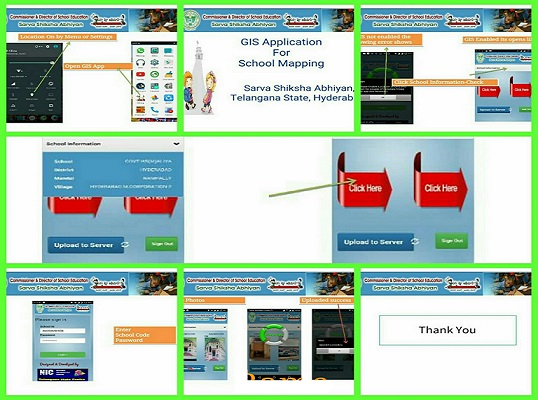
- Before logging into application, make sure to enable Internet connection (Mobile data) and GPS(Location) activation (Otherwise the application does not work).
- After enabling the Mobile data & GPS location, wait for few minutes to start the app. Once Mobile data & GPS are enabled then only you have to start the app.
- User can logon to the app. by using their childinfo application school level credentials.
- Take the School Photographs in horizontal mode.
- If the above procedure is not followed, we may not get accurate Geo-Coordinates .
Note:
At a time, only two photographs can be captured. User can repeat the process to capture more than 2 photographs per school.
The following photographs are to be uploaded :
2.Compound Wall
3.Toilets-Boys &Girls
4.Drinking Water
5.Electricity
6.Kitchen Shed
7.Library
8.Lab (Science /Computer)
Installation & Setup :
- One Android Mobile Phone with Internet 2G or 3G activated.
- Please enable the GPS location in the mobile phone.
- Open-Settings- Location- On/Off-Select On
- http://ssa.tg.nic.in Right click save
Username : UDISE CODE
Password : Childinfo password
GIS Mapping App is available from 11-04-2016 onwards in Google Play store.
Official site : www.ssa.tg.nic.in
SSA TS MobileApp Instructions
TS Govt to fill (399) NIMS vacancies through direct recruitment TS GO 59
Rayalaseema University (RUK ) Degree Exams Results 2020 | Year wise and Semester wise.